Atlantic Ocean is an second largest ocean of the planet. It is located between Greenland and Iceland in the north, Europe and Africa in the east, North and South America in the west and Antarctica in the south. The coastline of the ocean is strongly indented in the Northern Hemisphere and weakly in the Southern. The greatest depth is 8742 m in the gutter Puerto Rico.
The area of the Atlantic Ocean with seas is 91.6 million km 2, the average depth is 3332 m, the maximum depth is 8742 m.
The Atlantic Ocean was formed after the collapse of Gondwana and Laurasia (in the Mesozoic), it is relatively young. The Mid-Atlantic Ridge stretches across the ocean in the meridional direction, which divides it into western and eastern parts.
The Atlantic Ocean is located in almost all climatic zones, except for the Arctic, but its largest part lies in the regions of the equatorial, subequatorial, tropical and subtropical climates. In the temperate latitudes of the Northern Hemisphere, strong westerly winds dominate, but they reach their greatest strength in the temperate latitudes of the Southern Hemisphere. Trade winds prevail in subtropical and tropical latitudes.
In the Atlantic Ocean, currents are well expressed, directed almost in the meridional direction. This is due to the large elongation of the ocean from north to south and the outlines of its coastline. The most famous warm current Gulfstream and its continuation - North Atlantic flow.
The salinity of the waters of the ocean as a whole is higher than the average salinity of the waters of the World Ocean, and organic world poorer in terms of biodiversity compared to the Pacific Ocean.
Since ancient times, the Atlantic Ocean has been mastered by people and is now considered the most developed. Important sea routes pass through the Atlantic, connecting Europe with North America and both of these parts of the world with the oil countries of the Persian Gulf. The shelves of the North Sea and the Gulf of Mexico are places for oil extraction. material from the site
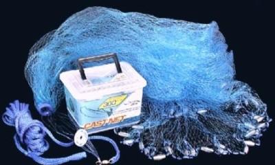
The seas of the Atlantic Ocean are the main fishing areas; up to half of the world's fish catch is caught here. The main fishing areas are the shelves, that is, the relatively shallow areas of the ocean. Herring fish (herring, sardines), cod fish (cod, haddock, navaga), mackerel, flounder, halibut, sea bass, eel, sprats, etc. are of commercial importance (Fig. 60). Unfortunately, the stocks of Atlantic herring and cod, sea bass and other fish species have sharply decreased. Today, the problem of preserving the biological and mineral resources of not only the Atlantic, but also the rest of the oceans is particularly acute. Fishing countries around the world agree on the allowable catch of fish and measures to combat poachers.
The area of the Atlantic Ocean with seas is 91.7 million km 2, which is about a quarter of the water area of the World Ocean. It has a unique configuration. It expands in the northern and southern parts, narrows in the equatorial to 2830 km and has a length from north to south of about 16,000 km. It contains about 322.7 million km 3 of water, which corresponds to 24% of the water volume of the World Ocean. About 1/3 of its area is occupied by the mid-ocean ridge. The average depth of the ocean is 3597 m, the maximum is 8742 m.
In the east, the ocean boundary runs from the Statland Peninsula (62°10¢ N 5°10¢ E) along the coast of Europe and Africa to Cape Agulhas and further along the 20° E meridian. to the intersection with Antarctica, in the south - along the coast of Antarctica, in the west - along the Drake Strait from Cape Sternek on the Antarctic Peninsula to Cape Horn in the Tierra del Fuego archipelago, along the coast of the South and North America to the southern inlet cape of the Hudson Strait, in the north along a conditional line - the southern inlet cape of the Hudson Strait, Ulsingem Cape (Baffin Island), Burnil Cape (Greenland Island), Cape Gerpyr (Iceland Island), Fugle Island (Faroe Archipelago), Mackle Island -Flagga (Shetland Islands), Statland Peninsula (62°10¢ N 5°10¢ E).
In the Atlantic Ocean, the coastline of Europe and North America is notable for its considerable indentation, the outlines of the coasts of Africa and South America are relatively simple. The ocean has several Mediterranean seas (Baltic, Mediterranean, Black, Marmara, Azov) and 3 large bays (Mexican, Biscay, Guinea).
The main groups of islands of the Atlantic Ocean of continental origin: Great Britain, Ireland, Newfoundland, Greater and Lesser Antilles, Canaries, Cape Verde, Falkland. A small area is occupied by volcanic islands (Iceland, Azores, Tristan da Cunha, St. Helena, etc.) and coral (Bahamas, etc.).
Peculiarities geographical location The Atlantic Ocean predetermined its significant role in people's lives. This is one of the most developed oceans. Since ancient times, it has been studied by man. Many theoretical and applied problems of oceanology were solved on the basis of research carried out for the first time in the Atlantic Ocean.
Geological structure and bottom topography. Underwater margins of the continents occupy about 32% of the area of the Atlantic Ocean. The most significant areas of the shelf are observed off the coast of Europe and North America. Off the coast of South America, the shelf is less developed and expands only in the Patagonia region. The African shelf is very narrow with depths from 110 to 190 m, complicated by terraces in the south. In high latitudes on the shelf, glacial landforms are widespread, due to the influence of modern and Quaternary continental glaciation. In other latitudes, the shelf surface is leveled by accumulative-abrasion processes. Practically in all shelf areas of the Atlantic there are relic flooded river valleys. From modern forms The relief is most widely represented by sand ridges formed by tidal currents. They are typical for the shelf of the North Sea, the English Channel, North and South America. In the equatorial-tropical latitudes, especially in the Caribbean Sea, near the Bahamas and the coast of South America, coral structures are common.
The slopes of the underwater margin of the continents in the Atlantic Ocean are mainly expressed by steep ledges, often with a stepped profile. They are everywhere dissected by submarine canyons and sometimes complicated by marginal plateaus. The continental foot in most areas is represented by an inclined accumulative plain lying at depths of 3000-4000 m. In some regions, large fans of turbidity flows are observed, among which fans of the Hudson, Amazon, Niger and Congo submarine canyons stand out.
transition zone in the Atlantic Ocean is represented by three areas: Caribbean, Mediterranean and South Sandwich or the Scotia Sea.
The Caribbean region includes the sea of the same name and the deep-water part of the Gulf of Mexico. Numerous uneven-aged island arcs of complex configuration and two deep-water trenches (Cayman and Puerto Rico) are located here. The bottom relief is very complex. Island arcs and submarine ridges divide the Caribbean Sea into several basins with depths of about 5000 m.
The transitional area of the Scotia Sea is a section of the underwater margin of the continents, fragmented by tectonic movements. The youngest element of the region is the island arc of the South Sandwich Islands. It is complicated by volcanoes and bordered on the east by the deep-water trench of the same name.
The Mediterranean region is distinguished by the predominance of the earth's crust of the continental type. The subcontinental earth's crust is found in separate sections only in the deepest basins. The Ionian Islands, Crete, Kasos, Karpathos and Rhodes form an island arc, accompanied from the south by the Hellenic Trench. The Mediterranean transitional region is seismic. Active volcanoes have been preserved here, including such as Etna, Stromboli, Santorini.
Mid-Atlantic Ridge begins off the coast of Iceland called Reykjanes. In plan, it has an S-shape and consists of northern and southern parts. The length of the ridge from north to south is about 17,000 km, the width reaches several hundred kilometers. The Mid-Atlantic Ridge is characterized by significant seismicity and intense volcanic activity. Most earthquake sources are confined to transverse faults. The axial structure of the Reykjanes Ridge is formed by a basaltic ridge with weakly expressed rift valleys. At a latitude of 52-53 ° N. sh. it is crossed by the Gibbs and Reykjanes transverse faults. From here begins the North Atlantic Ridge with a well-defined rift zone and numerous transverse faults. In the equatorial ridge is especially broken big amount faults and has a sublatitudinal strike. The South Atlantic Ridge also has a well-defined rift zone, but is less dissected by transverse faults and is more monolithic than the North Atlantic Ridge. The volcanic plateaus of the Ascension, the islands of Tristan da Cunha, Gough, and Bouvet are confined to it. At Bouvet Island, the ridge turns east, passes into the African-Antarctic and merges with the ridges of the Indian Ocean.
The Mid-Atlantic Ridge divides ocean floor into two almost equal parts. They, in turn, are crossed by transverse uplifts: the Newfoundland Ridge, the Ceara Rise, Rio Grande, the Cape Verde Islands, Guinea, Whale Ridge, etc. There are 2,500 individual seamounts in the Atlantic Ocean, of which about 600 are located within the ocean floor. A large group of seamounts is confined to the Bermuda Plateau. Guyots and volcanic mountain ranges are widely represented in the Azores region. Mountain structures and uplifts divide the ocean floor into deep-water basins: Labrador, North American, Newfoundland, Brazilian, Iberian, Western European, Canary, Angolan, Cape. The relief of the bottom of the basins is characterized by flat abyssal plains. In the areas of basins adjacent to mid-ocean ridges, abyssal hills are typical. In the north of the Atlantic Ocean, as well as in tropical and subtropical latitudes, there are many banks with a depth of 50-60 m. Over a larger area of the ocean floor, the thickness of the sedimentary layer exceeds 1 km. The oldest deposits of the Jurassic age.
Bottom sediments and minerals. Among the deep-water sediments of the Atlantic Ocean, foraminifera predominate, occupying 65% of the area of the ocean floor. Due to the warming effect of the North Atlantic Current, their range extends far to the north. Deep-water red clay occupies about 26% of the ocean floor area and occurs in the deepest parts of the basins. In the Atlantic Ocean, pteropod deposits are more common than in other oceans. Radiolarian muds are found only in the Angolan Basin. In the south of the Atlantic, siliceous diatomaceous oozes are widely represented, with a silica content of up to 72%. In some areas of the equatorial-tropical latitudes, coral silts are observed. In shallow areas, as well as in the Guinean and Argentine basins, terrigenous deposits are well represented. On the shelf of Iceland and the Azores plateau, pyroclastic deposits are widespread.
Bottom sediments and bedrocks of the Atlantic Ocean have a wide range of minerals. In the coastal waters of South West Africa there are deposits of gold and diamonds. Huge deposits of monazite sands have been discovered off the coast of Brazil. Large deposits of ilmenite and rutile are observed off the coast of Florida, iron ore - off Newfoundland and Normandy, cassiterite - off the coast of England. Iron-manganese nodules are scattered on the ocean floor. Oil and gas fields are being developed in the Gulf of Mexico, Biscay and Guinea, the North Sea, the Maracaibo lagoon, the Falkland Islands and a number of other places.
Climate The Atlantic Ocean is largely determined by the peculiarities of its geographical position, its peculiar configuration, and the conditions of atmospheric circulation.
Annual amount of total solar radiation varies from 3000-3200 MJ/m 2 in subarctic and antarctic latitudes to 7500-8000 MJ/m 2 in equatorial-tropical latitudes. The value of the annual radiation balance ranges from 1500-2000 to 5000-5500 MJ/m 2 . In January, a negative radiation balance is observed north of 40°N. sh.; in July - south of 50 ° S. sh. The balance reaches its maximum monthly value (up to 500 MJ/m2) in the tropics, in January in the southern hemisphere, and in July in the northern hemisphere.
The baric field over the Atlantic Ocean is represented by several centers of action of the atmosphere. In the temperate latitudes of the northern hemisphere, the Icelandic low is located, which is more active in winter. In the subpolar region of the southern hemisphere, the Antarctic Low Pressure Belt stands out. In addition, the formation of the climate of high latitudes Pacific Ocean the Greenland High and the Antarctic high-pressure region have a significant influence. In the subtropical latitudes of both hemispheres above the ocean, there are centers of two permanent baric maxima: the North Atlantic (Azores) and the South Atlantic. Along the equator is the equatorial depression.
The location and interaction of the main baric centers determines the system of prevailing winds in the Atlantic Ocean. At high latitudes, easterly winds are observed off the coast of Antarctica. In temperate latitudes, westerly winds predominate, especially in the southern hemisphere, where they are most constant. These winds cause a significant frequency of storms throughout the year in the southern hemisphere and in winter in the northern hemisphere. The interaction of subtropical highs and equatorial depression causes the formation of trade winds in tropical latitudes. The frequency of trade winds is about 80%, but they rarely reach storm speed. In the tropical part of the northern hemisphere in the Caribbean Sea, the Lesser Antilles, the Gulf of Mexico and the Cape Verde Islands, tropical cyclones are observed, with hurricane-force winds and heavy rainfall. On average, there are 9 hurricanes per year, most of which occur from August to October.
Seasonal changes are clearly visible in the Atlantic Ocean air temperature. The warmest months are August in the northern and February in the southern hemispheres, while the coldest months are February and August, respectively. In winter, in each hemisphere, the air temperature in the equatorial latitudes drops to +25 °С, in the tropical - to +20 °С and temperate - to 0 - - 6 °С. The annual amplitude of air temperature near the equator is not more than 3 °С, in subtropical regions up to 5 °С, in temperate regions up to 10 °С. Only in the extreme northwest and south of the ocean, where the influence of the adjacent continents is most pronounced, does the average air temperature of the coldest month drop to -25 °C, and the annual temperature amplitude reaches 25 °C. In the Atlantic Ocean, there are noticeable anomalies in the sublatitudinal distribution of air temperature near the western and eastern coasts of the continents, due to the influence of ocean currents.
Differences in atmospheric circulation conditions over the Atlantic Ocean affect the nature of cloudiness and precipitation in its waters. The maximum cloudiness over the ocean (up to 7-9 points) is observed in high and temperate latitudes. In the equatorial region, it is 5-b points. And in subtropical and tropical latitudes it decreases to 4 points. The amount of precipitation in polar latitudes is 300 mm in the north of the ocean and 100 mm in the south, in temperate latitudes it rises to 1000 mm, in subtropical and tropical latitudes it varies from 100 mm in the east to 1000 mm in the west, and in equatorial latitudes it reaches 2000-3000 mm.
A characteristic phenomenon for the temperate latitudes of the Atlantic Ocean are dense mists formed by the interaction of warm air masses with a cold water surface. Most often they are observed in the area of the island of Newfoundland and off the southwestern coast of Africa. In the tropical zone, fogs are rare and most likely around the Cape Verde Islands, where the dust carried from the Sahara serves as condensation nuclei for atmospheric water vapor.
hydrological regime. surface currents in the Atlantic Ocean are represented by two extensive anticyclonic gyres with centers near 30° north and south latitude.
The northern subtropical gyre is formed by the Northern Tradewind, Antilles, Florida, Gulf Stream, North Atlantic and Canary Currents, the southern one by the South Tradewind, Brazil, West Winds and Benguela. Between these gyres is the Equatorial Countercurrent (at 5-10°N), which passes into the Guinea in the east. The Lomonosov subsurface countercurrent is located under the South Equatorial Current. It crosses the ocean from west to east at a depth of 300-500 m, reaches the Gulf of Guinea and fades south of it. Under the Gulf Stream at a depth of 900-3500 m, at a speed of up to 20 km / h, a powerful subsurface Western Border bottom countercurrent passes, the formation of which is associated with a bottom runoff of cold water from high latitudes. In the northwest of the Atlantic Ocean, a cyclonic circulation is distinguished, consisting of the North Atlantic, Irminger, East Greenland, West Greenland and Labrador currents. In the eastern part of the Atlantic Ocean, the deep Lusitana current is well expressed, which is formed by the bottom runoff of Mediterranean waters through the Strait of Gibraltar.
Excitement in the Atlantic Ocean depends on the direction, duration and speed of the prevailing winds. The area of greatest wave activity is located north of 40°N. sh. and south of 40°S. sh. The height of waves during long and very winds sometimes reaches 22-26 m. Waves 10-15 m high are relatively often observed. Every year, during the passage of tropical cyclones, waves 14-16 m high are formed. In the northern part of the Atlantic in the Antilles, Azores, Canaries islands and off the coast of Portugal, storm surges 2-4 m high are quite often observed.
Most of the Pacific tides semi-diurnal. In the open ocean, the tide height usually does not exceed 1 m (St. Helena - 0.8 m, Ascension Island - 0.6 m). Off the coast of Europe in the Bristol Bay, tides reach 15 m, in the Gulf of Saint-Malo - 9-12 m. from.
Average annual surface water temperature The Atlantic Ocean is 16.9 °C. Its annual amplitude in the equatorial-tropical latitudes is no more than 1-3 °C, subtropical and temperate latitudes - 5-8 °C, polar - about 4 °C in the north and up to 1 °C in the south. In general, the temperature of the surface waters of the Atlantic decreases from the equator to high latitudes. In winter, in February in the Northern Hemisphere and in August in the Southern Hemisphere, it changes from +28 °С at the equator to +6 °С at 60° N. and -1°C at 60°S latitude, in summer, in August in the Northern Hemisphere and in February in the Southern Hemisphere: from +26 ° С at the equator to +10 ° С at 60 ° N and about 0 ° С at 60 ° S. sh. Ocean currents cause significant anomalies in the temperature of surface waters. Due to the significant inflow of warm waters from low latitudes, the northern area of the ocean is much warmer than its southern part. In some areas near the coasts of the continents, there are differences in the water temperature of the western and eastern sectors of the ocean. So, at 20° N. sh. the presence of warm currents maintains the water temperature in the west of the ocean at 27 ° C, while in the east it is only 19 ° C. Significant horizontal temperature gradients of the surface layer are observed at the meeting points of cold and warm currents. At the junction of the East Greenland and Irminger currents, a temperature difference of 7 ° C within a radius of 20-30 km is a common occurrence.
The Atlantic Ocean is the saltiest of all oceans. Medium salinity its waters is 35.4‰. The highest water salinity up to 37.9 ‰ is observed in tropical latitudes in the east of the Atlantic, where there is little precipitation and maximum evaporation. In the equatorial zone, salinity drops to 34-35 ‰, in high latitudes it drops to 31-32 ‰. The zonal distribution of salinity is often disturbed as a result of the movement of water by currents and the inflow of fresh water from land.
ice formation in the northern part of the Atlantic Ocean occurs mainly in the inland seas of temperate latitudes (Baltic, Northern, Azov) and the Gulf of St. Lawrence. IN open ocean a large amount of floating ice and icebergs is carried out of the Arctic Ocean. Floating ice in the northern hemisphere reaches 40°C even in July. sh. In the south of the Atlantic, ice and icebergs form in Antarctic waters. The main source of icebergs is the Filchner Ice Shelf in the Weddell Sea. South of 55°S sh. floating ice is present throughout the year.
Water transparency in the Atlantic Ocean varies widely. It decreases from the equator to the poles and from the coasts to the central part of the ocean, where the water is usually homogeneous and transparent. The maximum transparency of water in the Weddell Sea is 70 m, Sargasso Sea - 67 m, Mediterranean - 50, Black - 25 m, North and Baltic 18-13 m.
Surface water masses in the Atlantic Ocean have a thickness of 100 m in the Southern Hemisphere to 300 m in the equatorial-tropical latitudes. They are characterized by significant seasonal variability of properties, vertical uniformity of temperature, salinity and density. Subsurface waters fill depths up to about 700 m and differ from surface waters in increased salinity and density.
Intermediate water masses in the northwestern part of the ocean are formed as a result of immersion of cold waters coming from high latitudes. Salt waters from the Mediterranean Sea form a special water intermediate mass. In the Southern Hemisphere, intermediate water is formed by subsidence of cooled Antarctic waters and is characterized by low temperature and low salinity. It moves to the north, first at a depth of 100-200 m, gradually sinks further north of 20°N. sh. at a depth of 1000 m it mixes with the northern intermediate water.
The deep water masses of the Atlantic Ocean consist of two layers of different genesis. The upper horizon is formed by the subsidence of warm and salty Mediterranean waters. In the northern part of the ocean, it is located at depths of 1000-1250 m, in the Southern Hemisphere it drops to 2500-2750 m and wedges out at about 45 ° S. sh. The lower layer of deep water is formed mainly as a result of the sinking of the cold waters of the East Greenland Current from depths of 2500-3000 m in the northern hemisphere to 3500-4000 m at 50 ° S. sh., where it begins to be displaced by bottom Antarctic waters.
Bottom water masses are formed mainly on the Antarctic shelf and gradually spread over the ocean floor. North of 40°N the presence of bottom water coming from the Arctic Ocean is noted. They are characterized by uniform salinity (34.6-34.7 ‰) and low temperature (1-2 °C).
organic world. The Atlantic Ocean is inhabited by a variety of plant and animal species. The phytobenthos of the temperate and polar latitudes of the Atlantic is characterized by brown and red algae. In the equatorial-tropical zone, the phytobenthos is represented by numerous green algae (caulerpa, wallonia, etc.) of the red ones, lithotamnia predominate, and of the brown ones, sargasso ones. On the littoral of the European coast, sea grass - zostera - is widely represented.
Phytoplankton of the Atlantic Ocean has 245 species. They are represented by an approximately equal number of peridine species, coccolithophorids, and diatoms. The latter have a clearly defined zonal distribution and live mainly in temperate latitudes. The fauna of the Atlantic has a smaller number of species than in the Pacific Ocean. But some families of fish (codfish, herring, etc.) and mammals (seals, etc.) are much richer in the Atlantic Ocean. The total number of species of whales and pinnipeds is about 100, fish are more than 15,000. Of the birds, albatrosses and petrels are common. The distribution of animal organisms has a well-pronounced zonal character, and not only the number of species, but also the total biomass changes zonally.
In the subantarctic and temperate latitudes, the biomass reaches its maximum, but the number of species is much less than in the equatorial-tropical zone. Antarctic waters are poor in species and biomass. The fauna of the subantarctic and temperate zones of the southern part of the Atlantic Ocean is dominated by: in zooplankton - copepods, pteropods, among mammals - whales and pinnipeds, among fish - nototenidae. In the temperate latitudes of the Northern Hemisphere, foraminifers and copepods are most characteristic of zooplankton. Of the commercial fish, the most important are herring, cod, haddock, halibut, and sea bass.
In the equatorial-tropical zone, zooplankton consists of numerous species of foraminifera and pterapods, several species of radiolarians, copepods, larvae of mollusks and fish. These latitudes are characterized by sharks, flying fish, sea turtles, jellyfish, squids, octopuses, corals. Commercial fish are represented by mackerel, tuna, sardines, anchovies.
The deep-sea fauna of the Atlantic Ocean is represented by crustaceans, echinoderms, specific genera and families of fish, sponges, and hydroids. Endemic species of polychaetes, isopods and holothurians live in the ultraabyssal zone.
There are four biogeographic regions in the Atlantic Ocean: Arctic, North Atlantic, Tropical Atlantic and Antarctic. Of the fish for the Arctic region are characteristic - haddock, cod, herring, saury, sea bass, halibut; North Atlantic - cod, haddock, saithe, various flounders, in more southern regions - wrasse, mullet, mullet; Tropical-Atlantic - sharks, flying fish, tuna, etc.; Antarctic - noto-shadow.
The following are distinguished in the Atlantic Ocean physical-geographical zones and regions. Northern subpolar belt: Labrador Basin, Denmark Strait and waters of Southeast Greenland, Davis Strait; northern temperate zone: the area of the American shelf, the Gulf of St. Lawrence, the English Channel and the Pas de Calais, the Irish Sea, the Celtic Sea, the North Sea, the Danish (Baltic) Straits, the Baltic Sea; northern subtropical belt: Gulf Stream, Gibraltar region, Mediterranean Sea, Black Sea straits and Sea of Marmara, Black Sea, Sea of Azov; northern tropical belt: West African Region, American Mediterranean Sea with subregions: Caribbean Sea, Gulf of Mexico, Bahamas Subregion; equatorial belt: Gulf of Guinea, Western Shelf; southern tropics: Congo region; southern subtropical belt: La Plata region, South West Africa region; southern temperate zone: Patagonian region; southern subpolar belt: Sea of Scotia; south polar belt: Weddell Sea.
From the article you will learn which continents are washed by the Atlantic Ocean and how it affects them.
Characteristics of the Atlantic Ocean
The ocean covers an area of 91.66 million square kilometers. km, making it the second largest after the Pacific. More than 16% of its total area falls on the straits, seas and bays. The salinity of the water is approximately 34-37 ppm. The deepest point is the Puerto Rico Trench, 8,742 meters deep. The average depth of the Atlantic Ocean is about 4 kilometers, and this is less than that of the Pacific and Indian.
The Atlantic is located in all 4 hemispheres and washes 5 continents. The Danish Strait and the Davis Strait in the north connect it to the North Arctic Ocean. in the south it communicates with the Pacific Ocean, and with the Indian Ocean it is connected by the water space between Antarctica and Africa.
Previously, the Atlantic Ocean was called the Western, Outer, North Sea, now the term "Atlantic" is often used to refer to it. On a European map, authored by the Dutchman Varenius, the modern name of the ocean appeared in 1650.
The origin of the name "Atlantic Ocean" is associated with the African Atlas Mountains. Scientists suggest that even among the ancient Greeks, this name literally meant "the sea beyond the Atlas Mountains." There are two more versions of the name - one connects it with the sunken Atlantis, the other - with the name of the titan Atlanta.
Atlantic exploration
People began to explore the described expanses of water earlier than other oceans, through the waters of the Mediterranean Sea. Even before our era, ancient peoples founded cities and states on the shores of the Mediterranean. Watching the ebb and flow, animals and flora, they were the first explorers of these waters.
Of course, in ancient times, people did not know exactly which continents were washed by the Atlantic Ocean. Their geographical knowledge differed markedly from modern ones. Nevertheless, Pytheas made voyages across the North Atlantic as early as the 4th century BC. And in the 10th century AD, Eric the Red, originally from Normandy, undertook the first voyage across the Atlantic Ocean, arriving on the shores of the island of Newfoundland.

- Brazilian;
- Guiana;
- Gulf Stream;
- Norwegian.
The cold currents of the Atlantic contribute to a colder and drier climate along the coasts. So, the Labrador current forms a harsh climate on the island of Labrador, and the Benguela and Canary currents make the climate of the West African coast dry. The collision of the Gulf Stream with the Labrador Current provides prolonged fogs on the shores of Newfoundland.

Cold currents of the Atlantic Ocean:
- Greenlandic;
- Labrador;
- Canarian;
- Benguela.
Conclusion
Now we know which continents the Atlantic Ocean washes and what effect it has on them. Stretching from north to south, this expanse of water has long been of great importance to people. The waters of the Atlantic connect the five continents together and significantly affect their weather conditions.
Atlantic Ocean- the second largest ocean after the Pacific Ocean. It contains 25% of the world's water. The average depth is 3,600 m. The maximum depth is in the Puerto Rico trench - 8,742 m. The ocean area is 91 million square meters. km.
general information
The ocean arose as a result of the split of the supercontinent Pangea» into two large parts, which subsequently formed into modern continents.

The Atlantic Ocean has been known to man since ancient times. Mentioning the ocean, which " called the Atlantic“, can be found in the records of the 3rd c. BC. The name probably originated from the legendary missing mainland " Atlantis«.

True, it is not clear what territory it designated, because in ancient times people were limited in their means of transportation by sea.
Relief and islands
A distinctive feature of the Atlantic Ocean is the very small amount islands, as well as the complex bottom topography, which forms many pits and gutters. The deepest among them are the Puerto Rico Trench and the South Sandwich Trench, which are over 8 km deep.

Earthquakes and volcanoes have a great influence on the structure of the bottom, the greatest activity of tectonic processes is observed in the equatorial zone.
 Volcanic activity in the ocean has been going on for 90 million years. The height of many underwater volcanoes exceeds 5 km. The largest and most famous are found in the Puerto Rico and Yuno Sandwich trenches, as well as on the Mid-Atlantic Ridge.
Climate
The large meridional extent of the ocean from north to south explains the diversity of climatic conditions on the surface of the ocean. In the equatorial zone, there are slight temperature fluctuations throughout the year and an average of +27 degrees. The exchange of water with the Arctic Ocean also has a huge impact on ocean temperature. From the north, tens of thousands of icebergs drift into the Atlantic Ocean, reaching almost tropical waters.

The Gulf Stream, the largest current on the planet, is born off the southeastern coast of North America. Water consumption per day is 82 million cubic meters, which is 60 times higher than the flow of all rivers. The width of the current reaches 75 km. wide, and the depth is 700 m. The speed of the current varies between 6-30 km / h. The Gulf Stream carries warm waters, the temperature of the upper layer of the current is 26 degrees.

In the area of The Newfoundland Gulf Stream meets the cold wall of the Labrador Current. A mixture of waters is created ideal conditions for the propagation of microorganisms in the upper layers. Best known in this regard Large Newfoundland barrel, which is a source of fishing for fish such as cod, herring and salmon.
Flora and fauna
The Atlantic Ocean is characterized by an abundance of biomass with a relatively poor species composition in the northern and southern margins. The greatest species diversity is observed in the equatorial zone.

Of the fish, the most common are the families of nanoteniy and white-blooded pikes. Large mammals are most widely represented: cetaceans, seals, fur seals, etc. The amount of plankton is insignificant, which causes whales to migrate to feeding areas to the north or to temperate latitudes, where it is more abundant.

Many places in the Atlantic Ocean have been and continue to be intensive fishing grounds. Earlier development of the ocean has led to the fact that hunting for mammals has been common here for a long time. This has reduced the number of some animal species compared to the Pacific and Indian Oceans. 
Plants are represented by a wide range of green, brown and red algae. The famous sargasso form a popular book and interesting stories Sargasso Sea.

In the school course of studying the oceans, the Atlantic must be passed. This water area is quite interesting, which is why we will pay attention to it in our article. So, here is the characteristic of the Atlantic Ocean according to the plan:
- Hydronym.
- Basic moments.
- Temperature regime.
- Salinity of water.
- Seas and islands of the Atlantic Ocean.
- Flora and fauna.
- Minerals.
- Problems.
You will also find here a brief comparative description of the Pacific and Atlantic oceans.
hydronym
The Atlantic Ocean, whose characteristics are presented below, got its name thanks to the ancient Greeks, who believed that the hero of myths, Atlas, holds the sky at the edge of the Earth. The modern name was established in the 16th century, during the time of great navigators and discoveries.
Basic moments
The Atlantic Ocean stretches along the globe from north to south from Antarctica to Antarctica, washing 5 continents: Antarctica, North and South America, Eurasia and Africa. Its area is 91.6 million square kilometers. The deepest point of the Atlantic is the Puerto Rican Trench (8742 m), and the average depth is about 3.7 thousand m.
A characteristic feature of the second largest ocean is its elongated shape. The Mid-Atlantic Ridge runs along the Atlantic, which separates South American, Caribbean and North American in the west; in the east - African and Eurasian. The length of the ridge is 16 thousand km, and the width is about 1 km. Lava eruptions and earthquakes often occur here. The discovery of the Mid-Atlantic Ridge is associated with the laying of a telegraph cable that connected America and Northern Europe in the middle of the 19th century.
Temperature regime
The North Trade Wind, Gulf Stream, North Atlantic, Labrador, Canary and others are currents that shape not only the climate, but the entire Atlantic Ocean. The characteristic of the temperature regime shows the following dynamics: the average water temperature is about 16.9 °C. Conventionally, the ocean can be divided along the equator into 2 parts: northern and southern, each of which has its own climatic features, thanks to the Gulf Stream. The width of the water area near the equator is the smallest, so the influence of the continents is most noticeable here.
Despite the fact that the Atlantic Ocean is considered warm, its extreme southern and northern sections can reach temperatures of 0 ° C and below. Therefore, drifting icebergs can often be found here. Today, their movement is tracked by artificial Earth satellites.
Atlantic Ocean: water feature
The Atlantic Ocean is the most salty. The average salt content is 34.5 ppm. Salinity largely depends on precipitation, fresh water inflow from rivers. The most salty is in tropical latitudes, because there is almost no precipitation here, strong evaporation of moisture due to high temperatures, and almost no fresh water. 
Seas and islands of the Atlantic Ocean
Most of the islands are located near the mainland, which determines their continental origin: Great Britain, Ireland and others. There are also volcanic ones here: Canaries, Iceland. But Bermuda is of coral origin.
The indentation of the coastline, bays, seas fully describe the Atlantic Ocean. The characteristics of these reservoirs are very interesting. First of all, let's start with the seas. They are divided into 2 types: internal - Azov, Black, Mediterranean, Baltic, and external - Caribbean and Northern, etc. Also here you can observe bays that are not inferior in size to the seas, for example, Mexican or Biscay. In the Atlantic Ocean there is an unusual sea that has no shores - Sargasso. It got its name because of the sargassum seaweed with which its bottom is covered. These algae are covered with air bubbles, which is why they are also called
Flora and fauna
The organic world of the Atlantic is characterized by a variety of living organisms. Here grow red, brown, green algae, a large number of species of phytoplankton (more than 200). Thousands of species of animals live in cold zones, and tens of thousands in warm tropical zones. Whales, seals, fur seals, a lot of fish swim in the Atlantic Ocean: cod, herring, flounder, sardine, etc. Penguins and frigatebirds live in the northern latitudes. Large aquatic animals manatees live off the coast of Africa. They eat plants, which is why they are also called
It so happened historically that the Atlantic Ocean has become a source of fish for Food Industry(2/5 of the world catch). Whales, walruses, seals and other animals are also hunted here. It satisfies our needs for lobster, oysters, lobsters, crabs. 
Minerals
The ocean floor is very rich in various things and Canada mines coal here. Mexican and have large reserves of oil and natural gas.
Problems
The increase in anthropogenic influence on the Atlantic Ocean has a negative impact on its inhabitants, and it is no longer able to restore its biological resources on its own. A dangerous situation is observed in the Black and Mediterranean Seas, and the Baltic Sea is considered one of the dirtiest in the world. 
Comparative characteristics of the Atlantic Ocean and the Pacific (briefly)
In order to make a brief description of the two oceans, you need to use a clear plan:
- The size of the water areas. Atlantic covers an area of more than 91 million square meters. km, Quiet - 178.684 million square meters. km. Based on this, certain conclusions can be drawn. The Pacific Ocean is the largest, the Atlantic - in second place in terms of area.
- Depth. If we compare the depth indicator, then in the Pacific Ocean the average level stops at 3976 m, in the Atlantic - 3736 m. As for the maximum depth, in the first case - 11022 m, in the second - 8742 m.
- Water volume. According to this criterion, the Atlantic Ocean also remains in second place. His figure is 329.66 million cubic meters. km, when in the Pacific - 710.36 million cubic meters. m.
- Location. Atlantic Ocean coordinates - 0° N. sh. 30°W D., washes the following continents and islands: Greenland, Iceland (north), Eurasia, Africa (east), America (west), Antarctica (South). Pacific Ocean coordinates - 009 ° s. sh. 157°W e, located between Antarctica (south), North and South America (east), Australia and Eurasia (west).
Summing up
This article presents a brief description of Atlantic Ocean, having familiarized yourself with which, you can already have a sufficient idea of \u200b\u200bthis area.